Your phone dies at mile 8. The trail disappears into a boulder field. Suddenly, all those navigation skills you meant to practice feel very relevant.
GPS technology has made backcountry travel more accessible, but it’s also created a dangerous dependency. Batteries drain faster in cold weather, signals drop in deep canyons, and screens crack. The hikers who stay safe treat GPS as the first layer of a three-tier system, not the only one.
The Three-Tier Navigation Framework
Think of wilderness navigation as a redundancy stack. Each layer backs up the one before it, so when one fails, you’re not stranded.
- Digital primary: GPS apps like Gaia GPS or a dedicated Garmin unit work well when charged and functional.
- Analog backup: A topographic map and baseplate compass require zero battery. As one experienced backpacker put it, “AllTrails or Gaia GPS or a Garmin is just so much better than a paper map and compass IF you have power. I bring a paper map and compass as backup.”
- Natural navigation tertiary: Celestial and terrain-based cues apply when everything else is gone.
Most people have tier one covered. Almost nobody has practiced tier three before they actually need it.
Celestial Navigation: What Works and What Doesn’t
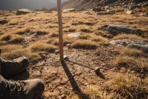
The shadow-tip method is one of the most cited techniques in natural navigation guides for backcountry hikers, but it’s rarely explained fully. Place a stick vertically in the ground and mark the tip of its shadow. Wait 15 minutes, then mark the new shadow tip. A line drawn from the first mark to the second points roughly east, though this works best at midday, at lower latitudes, and when the sun sits at least 20 degrees above the horizon.
For night navigation, Polaris sits within one degree of true north and doesn’t require any timing. Locate the Big Dipper’s two outer pointer stars and follow them upward five times their distance to find it.
Natural Terrain Cues: Reliable vs. Myth
The moss-grows-on-the-north-side rule gets repeated constantly and trusted far too easily. In dense forest with competing light sources, canopy gaps, and moisture variation, moss distribution is unreliable enough that using it as directional guidance can actively mislead you.
Terrain-based cues that actually hold up:
- Snow melts faster on south-facing slopes in the northern hemisphere
- Water always flows downhill toward lower elevation and, eventually, civilization
- Prevailing winds in most of North America come from the west, leaving asymmetrical tree growth on exposed ridges
Use any single cue as a hypothesis, not a fact. Cross-verify with at least two independent signals before committing to a direction.
Map and Compass: The Gap Between Knowing and Doing
Reading a topographic map is a learnable skill, but most hikers have never practiced declination adjustment with actual numbers. Magnetic declination in the western United States runs 10 to 15 degrees east, meaning a compass bearing taken without adjustment can put you significantly off course over distance.
The practical fix is straightforward: check the declination value printed on your topo map, then rotate your compass housing accordingly before taking any bearing. Free topo maps are available through USGS and platforms like CalTopo, and printing one before your trip takes about five minutes.
Pre-Trip Preparation as Your First Line of Defense
The best navigation decision happens before you leave the trailhead. Study your topo map until you can visualize the terrain: where ridgelines run, which drainages flow which direction, and where the trail crosses elevation bands.
One practical exercise from the bushcraft community involves sketching terrain features on graph paper at a scale of 1/4 inch to 100 meters after each hike. As one practitioner explained, “this will etch that map into your brain.” Doing this on familiar trails builds the spatial memory you’ll need when the terrain is unfamiliar.
If you’re evaluating dedicated navigation tools that work offline and in low-signal environments, our GPS device and navigation gear breakdown covers the options worth considering.
If You’re Already Lost: A Sequence That Works
Stop moving. Panic leads to compounding errors. Retrace your last confirmed position mentally before taking any action, and if you have a map, orient it to the terrain using visible landmarks rather than the compass alone.
Follow water downhill only after confirming the drainage doesn’t lead into a canyon or cliff system. Stay on high ground if you need to signal for rescue, and mark your path with cairns or flagging as you move so you have a backtrack option.
The minimum viable practice: On your next familiar trail, leave the GPS in your pocket and navigate by map and terrain observation alone. That single habit closes most of the gap between knowing these techniques and being able to use them when it counts.


Comments